
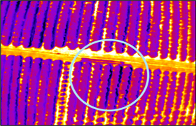
 Multispectral imaging, agricultural monitoring for example of crops and other vegetation is used in the identification of crop stress such as shortage or abundance of nutrients or water. Pests, disease, infections, spores and other plant stressors also leave their spectral mark on a plant, and can be identified easily from the air. This offers a great aid to farmers to identify and correct problems in their crops before too much damage is done, and also to optimise fertilisation patterns maximising production, while minimising the use of chemicals in food production.
LIDAR MAPPING | THERMAL IMAGING | CROP & FORESTRY SURVEY
Industrial drones @ Professional-Multirotors.com:
www.professional-multirotors.com/industrial-drones
For more: info (at) professional-multirotors.com